3 October 2025 — As autumn firmly settles in, the UK braces for one of the season’s most powerful storms yet. Storm Amy, the first named storm of 2025–26, is poised to unleash damaging winds, heavy rain, and wide disruption across northern and western Britain. Meteorologists have upgraded warnings, and officials are urging residents to prepare for what has been described as a “danger to life” event.
From the Atlantic: How Amy Is Forming
Storm Amy’s origin lies in the North Atlantic, where a deep low-pressure system is merging with the remnants of Hurricanes Humberto and Imelda. This interaction has fueled explosive intensification, sometimes called “explosive cyclogenesis”, which causes the storm to deepen rapidly as it approaches the UK.
The Met Office, in its forecast briefing, notes that this coupling with tropical systems is relatively unusual for October—and raises the potential for a storm with both strong wind and heavy rain.
Warnings Upgraded: Where Amy Will Hit Hard
Scotland First in the Crosshairs
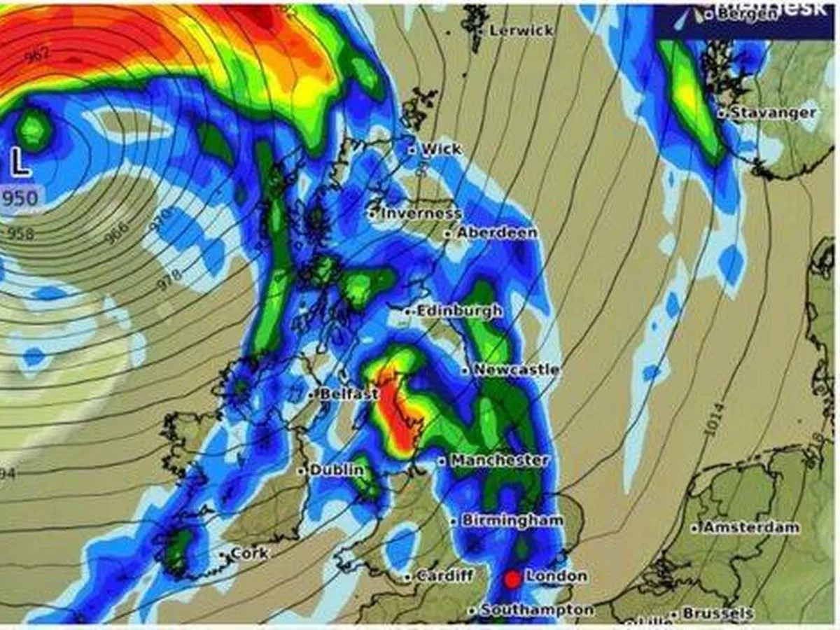
Parts of Scotland have been placed under Amber wind warning—the second-highest level—between 5 p.m. Friday and 9 a.m. Saturday. In these zones, gusts could hit 95 to 100 mph, particularly close to coasts, hills, and exposed terrain. The amber alert reflects the real risk to life from flying debris, structural damage, and falling trees.
Elsewhere across northern and western Britain, yellow warnings cover wind and rain—regions including Northern Ireland, northwest England, parts of Wales, and far north England. EXPECT widespread gusts of 60–70 mph, with heavier bursts in exposed locations.
Heavy rainfall is also expected, especially over western Scotland. Some areas could see 30–50 mm (or more) within a 6–9 hour window, increasing flood risk.
Maps from meteorological services indicate that the worst wind zones will stretch across the Scottish Highlands, Argyll & Bute, Moray, Orkney & Shetland, and parts of western Scotland.
Anticipated Disruptions & Risks
Transport Chaos Expected
Storm Amy’s fury is likely to turn travel into a nightmare:
- Roads: Flooded or debris-littered routes may force closures. High-sided vehicles are especially vulnerable.
- Rail & Ferries: Lines and ferry routes in affected zones may be suspended.
- Flights: Airports in Scotland and across northern England may face delays or cancellations.
Transport Scotland and other regional operators have already cautioned passengers to check before traveling.
Power, Infrastructure & Community Impacts
With gusts nearing 100 mph in some places, power outages are expected. Falling trees and debris could knock out supply lines, disrupt broadband, and cause chaos in more remote areas.
Properties may suffer damage—loose tiles, broken windows, gutter collapse. Coastal areas may see wave overtopping, beach material thrown inland, and sea spray affecting roads and structures.
Communities in low-lying or flood-prone zones should watch for river rises, surface water flooding, and blocked drains aggravated by leaves and debris.
Voices from Frontline Weather Services
In Scotland, STV News reports that in highland and exposed areas, wind gusts of 95–100 mph are anticipated, raising alarm over danger to life.
On the Met Office blog, the team describes Storm Amy as “bringing amber weather warning to UK,” warning that the northern two-thirds of the country could be affected by rain and wind.
Transport officials warn that journeys on Friday evening and overnight may be the worst hit. They advise avoiding travel when possible and leaving early if necessary.
Historical Context: How Amy Compares
Naming storms in the UK and Ireland began in 2015 to improve public awareness. Amy is the first in the 2025–26 season.
By wind strength, Amy ranks among Britain’s stronger seasonal storms. While gusts may not reach record highs, its combination of rapid intensification and coastal effects make it especially dangerous. The Met Office has compared it with past storms known for similar combined wind and rain impact.
How to Prepare & Stay Safe
To reduce risks during Storm Amy:
- Stay informed via Met Office alerts, local media, and weather apps.
- Secure property: bring in garden furniture, loose objects, reinforce windows.
- Avoid travel during warning periods if possible.
- Have emergency kits ready (torches, batteries, first aid, food, water).
- Know evacuation routes if in vulnerable zones.
- Check on neighbours, especially the elderly or those with limited mobility.
- Follow instructions from local authorities and emergency services.
What Comes Next
Storm Amy will gradually track northeast, affecting Scotland most severely, before moving away. Afterward, a brisk northwesterly flow could bring further showers and gusty winds.
Meteorologists emphasize uncertainty remains—small shifts in track or intensity can significantly change which areas are hardest hit.
As the UK faces its first major test of the 2025 storm season, Storm Amy is more than just another weather event—it may serve as an early indicator of what this winter’s volatile weather holds.